Wednesday, July 31, 2013

Metacomet trail - Part 4

This hike occurred on July 27, 2013


Trail Heads:

400 Park Dr., Berlin, CT Parking: Given our past experience with the auto road, we initially assumed we would not be able to access the peak inside Hubbard park by car so we parked on Park Dr back beyond the "no parking beyond this sign." We walked to the gate and were very aggravated to see cars and motorcycles riding up the auto road. So we turned around, got in our car, and drove 10 minutes around the park to enter via the auto road. We had a friend pick us up from this location at the end of our hike and bring us back to our car. On this road, we saw some awesome Castle Crashers art. 

Peak Dr., Meriden, CT - Parking: Using the Hubbard Park auto road, we parked at the top of the Hanging Hills' East Peak, near Castle Craig.  

Length/Distance: According the Connecticut Walk book, the route was 1.1 miles. According to my GPS tracking program, our route was 1.8 miles. After much deliberation, we've come to the determination that we think the Connecticut Forest & Park Association measures trail distance according to 2D maps, not the actual 3D mileage.  

Summary: We began our hike from Peak Drive and the turret. 
There were some beautiful views from the top of Castle Craig. 

You could see a clear view of Sleeping Giant State Park in the distance (giant's head to the right with the feet to the left). 
There was a good view of Mirror Lake. 
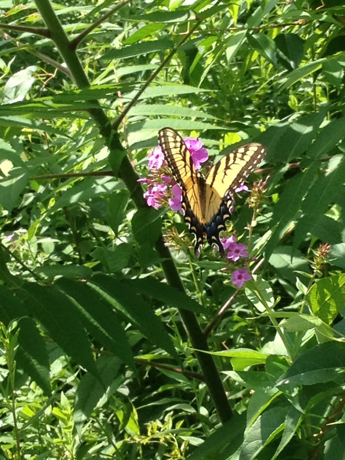
After taking pictures, we headed out on the blue trail. If you head out from the turret, the trail is on your right a few hundred yards away. The blue trail crosses over the white trail and then has more amazing views. As we were looking at the view, we realized that an inventive Eastern Ratsnake (Pantherophis alleghaniensis) was sunning itself in an evergreen bush around shoulder height and we had disturbed it (its head is dead center of the photo). 
There was also an interesting chasm between two cliffs. 
Along this trail, there were amazing views of the Merimere Reservoir.   
There was also a proliferation of ripe American Red Raspberry (Rubus idaeus) along the trail.
The trail passed over an old stream bed that had run over rock.
The trail emerged onto the auto road to pass by the base of the Merimere Reservoir. 
There was also some beautiful Queen Anne's Lace (Daucus carota) [which I've somehow forgotten is another name for wild carrots and the taproot is edible, though the leaves are toxic and can irritate skin]. 
We then left Hubbard Park via Park Drive and walked along the road to meet our friend who was picking us up. Along the way, we saw some beautiful Perennial Phlox (Phlox paniculata).
There was a female Eastern Tiger Swallowtail Butterfly (Papilio glaucus) drinking nectar from these flowers. 


Overall, the hike was fairly short and mostly downhill. The parking/road situation around Hubbard Park is very frustrating, given the inconstant accessibility. Since the next section of trail climbs one of the highest peaks on the Metacomet trail (West Peak - 1,024 ft elevation), we'll be splitting it into two hikes. 

Tuesday, July 30, 2013

Sleeping Giant - Triangle and Circle trails

This hike occurred on July 26, 2013
Trail Head:
Mt Carmel Ave & Outer Ridge Rd, Hamden, CT - Parking: There is a parking lot on Mt Carmel Ave with room for maybe 3 cars to park off the road. The entrance to Circle trail is accessible either from the road or from a connector trail from the parking lot. We were originally going to start the hike from Triangle trail by Hogan Rd but there is absolutely no parking. We left one car here and did one large loop. 

Length/Distance: 
We completed a loop hike, taking the Circle trail through to Tuttle Ave then Triangle trail back which was slated to be around 3-4 miles. According to my GPS tracking program, our route was 3.77 miles, not including the half-mile walk back to the Circle trail parking lot.   

Summary: We started the hike up the connector trail from the parking lot. The connector trail wasn't marked at all but follow it to the left and it connects with Circle trail. There was quite a bit of flora by the trail. We saw Narrow-Leaf Mountain Mint (or Slender Mountain Mint) (Pycnanthemum tenuifolium). Apparently, the dried leaves can be used as a flavorant in tea or cooking. It can be used as an insect repellent, though its cousin is better.  
Circle trail wound around the giant's right leg and knee and left leg. 
There had been a fair amount of rain lately and there was water running in creek beds that didn't typically have water. 
We also happened upon a camp site. Now, normally camping is not allowed on Sleeping Giant but if a non-profit organization or kids' camp wants to camp, they can get a permit. We did not know this so we called the DEEP and told them about the abandoned camp. They came out, took at look at it, contacted the owner of an abandoned trailer with camping supplies on it, and found out they were camping there legally as part of a non-profit kids' camp. The DEEP officer was kind enough to call us and let us know. 
The site was quite a mess though. We think they abandoned camp part way through their stay due to the rain. 
Right around here, there was the Gorge Cascade. It's a lot further down than it looks. 
We hit the bottom of the Circle trail and connected through to the Triangle trail via the horseback riding trail (U). The Triangle trail was a never-ending uphill climb up and over the giant's hips. 
There were some Intermediate Woodfern (Dryopteris intermedia) along the trail
Between the Orange and the White trails, there was a large tree down on Triangle trail. 
Towards the end of this hike, there was a nice wood bridge over a creek bed. 
From there, the trail exited onto the side of Mt Carmel Ave. We trekked back to our car at the base of the Circle trail.

Overall, it was a good but tiring hike. The Triangle trail was especially steep and had a very prolonged assent. It had been raining earlier in the day but had stopped prior to the beginning of the hike though it did drizzle on us during the middle of the hike.         

Friday, July 26, 2013

Metacomet trail - Part 3

This hike occurred on July 21, 2013
Trail heads:
100 Summit Wood Dr., Berlin, CT - Parking: After our last hike, we decided to park on the side of the road on Summit Wood Drive. There were signs posted near the cul de sac saying "no parking beyond this sign" but there was plenty of space to park on the curb and the road was very quiet since it's a dead end. 

400 Park Dr., Berlin, CT - Parking: While the CT Walk book, the New England Trail website, and the Town of Meriden's website all state that Castle Craig has an auto road providing access to the East Peak from May 1st through October 31st from 10:00 a.m. to 4:45 p.m., it so happens they are all wrong. We attempted access via Hubbard Park Dr and Notch Rd prior to Park Dr and the roads were all blocked off with signs saying both "road closed" and "gate open 10am-4:45pm between May 1-Oct 31." We parked on Park Dr back beyond the "no parking beyond this sign." It was maybe a few tenths of a mile to walk in but it put us right where we needed to be. If you park here, just be mindful of the signs.     

Length/Distance: According the Connecticut Walk book, the route was 2.9 miles. According to my GPS tracking program, our route was 3.5 miles. 

Summary: We began our hike from Park Drive. We followed the road up to the gate (the blue trail goes to the left by the gate, btw). 
We went beyond the gate to get some pictures of the Merimere Reservoir. 
We backtracked to the gate, where the blue markings lead away from the reservoir back towards Chamberlain Highway. 
On the side of the trail, we saw what appears to be Common Selfheal/healall (Prunella vulgaris). It is in the mint family and apparently edible.
This section of the trail followed along what might have once been a creek bed. The trail was comprised of loose, unstable rocks. 
Soon after this, the trail opens up onto Elmere Reservoir. It was beautiful.  
The water tower had quite a lot of graffiti on it but looked nice from a distance. 
The pump house had a lot of razor wire (also known as barbed tape) surrounding it to discourage would-be trespassers. 
In the corner of the meadow, near where the trail reenters the woods, there was a large bush of American Red Raspberry (Rubus idaeus) with ripe berries. 
 
There was also some ripe Lowbush Blueberries (Vaccinium angustifolium) as well. 
After a bit more hiking, we passed over Chamberlain Highway; the blue trail was straight across the road and easy to see. Right after the highway, we crossed Cathole Brook.  
There was an entertaining blank sign board on the trail after the road crossing. 
The next section of trail had an assent and lots of spider webs. Ironically, I thought this section of the trail was some of the more dangerous we've hiked. When hiking near cliffs, it's fairly obvious the danger and how to avoid it. Here, the trail was very narrow and uneven with layer upon layer of unstable rocks with a sharp drop off to the left and more than once, we had the trail crumble away at the edges and fall down the hill. 
The trail was fairly well marked until the end of the section when the blazes just died out and the trail was overrun with grass and other plants. This is where the trail enters the woods from the Victoria Drive side. Note the blue blaze on the tree to the left. 
Victoria Drive may once have been a through road but is not longer, regardless of what Google Maps may tell you. 
From here, we walked up the road, though there were absolutely no blue blazes. The surrounding area was very nice, though the summer sounds were punctured with roars of half a dozen dirt bikes. 
This area was full of flowers and blossoms. We saw Early Goldenrod (Solidago juncea) [link has amazing guide to identifying different types of Goldenrod]. 
We also saw Black-eyed Susans (Rudbeckia hirta).
There was a pink flower, perhaps a Small Wild Bean (Strophostyles leiosperma).  
There was also Common Daisies (Chrysanthemum leucanthemum).
Up the road, there is an intersection with another road spur, though Victoria Drive continues straight (picture is taken looking backward). 
On the upper right hand side of this intersection, we saw blue blazes on a few trees. 
We followed them into the woods. 
That tree directed us to the next trail marker. 
And then there were no more. This area needs the markings removed or covered. It was very confusing to have blue marks remaining when the trail did not travel this way anymore. We tried to follow what we thought was the trail for a bit and found a huge patch of American Red Raspberry (Rubus idaeus) growing on a trap rock incline. 

There were also unripe Fox Grapes (Vitis labrusca). 
After nomming on lots of raspberries, we bushwhacked our way back to the road through 7-8 foot high prickers, grass, and vines. From here, we walked further up Victoria Drive until we saw the blue trail split off to the left. The blue arrow was hard to see through all the foliage.  
From here, the trail was easy to follow though the bugs got really bad on this part of the trail for some reason. 
There was also a large fire ring that someone had made. It appears that people camp out here. 
From here, it was a fairly short hike back to the dead-end of Summit Wood Drive. Right near our parking spot, there was a large patch of American Red Raspberry (Rubus idaeus) so we went raspberry picking! 

Overall, this hike wasn't difficult physically. The temperature was in the mid-80's and it was sunny with fairly low humidity. The parking and road closure issues were more frustrating than anything else. The lack of trail markings (or trail markings that were not actually the trail) along Victoria Dr was also an issue.