Tuesday, October 11, 2016

Fall AT section hike, day #18

Tuesday, October 11th, 2016
Start: Wapiti Shelter
End: Cross Ave/VA 634 - Pearisburg
Miles: 17.9 (+0.5 for side trails; ~2.0 road walking around town)

When I woke up this morning at 6:45am, it was ~40 degrees. I did my morning routine, and also gave Ray my fuel cannister since his died this morning. In thanks, he made me some tea. It was a welcome bit of warm in my belly before I headed out. I was out on trail by 7:45am.

I climbed up to a view (3896') from Wapiti Shelter (2603'). From there, I climbed past the radio tower (4027'), then down to Sugar Run Gap (3395'). I then climbed to another view (3910'), then down past Docs Knob Shelter (3541') to a spring (3150'). From there, I climbed up to a view (3693') and then Angels Rest (3550'); then went down, down, down to Cross Ave/VA 634 (2019') and Pearisburg.

I managed to make Cross Ave by 4pm, and walked to the post office over a mile away by 4:20pm, with only 10 minutes to spare before they closed. They were very friendly and helped me ship my trekking poles, water treatment chemicals, and tent poles/stakes home. After that, I walked over to Angel's Rest hiker haven; I was surprised to find no one there. I took a shower, changed clothes, left a note and $4, and then headed out to the Food Lion and the AYCE Chinese buffet. I stopped off at Food Lion for a few drinks (sweet tea, powerade, and a mango smoothie). I drank the tea and the smoothie and saved the powerade for later. I may have overdone the buffet but I did only manage to have 2 platefuls. Now I shall bum around the plaza until my ride gets here in an hour.

Fall AT section hike, day #17

Monday, October 10th, 2016 (Indigenous Peoples' Day)
Start: US 52/0 Days Inn
End: Wapiti Shelter
Miles: 26.4

I started out from US 52 around 7:45am. After the guy at the hostel persistently offered to slackpack me to VA 606, I took him up in the offer and changed my plans a bit. So I slackpacked the ~18 miles to VA 606, arriving by 2pm. I got my pack and was back on trail by 2:30pm.

Today's elevation was relatively gentle, all things considered. I passed by VA 612, Helveys Mill shelter, VA 611, Brushy Mountain (3101'), Jenny Knob shelter, VA 608/Lickskillet Hollow (where I saw signs for another new hostel), Kimberling Creek, VA 606, side trail to Dismal Falls, Dismal Creek, and then Wapiti shelter. I made the shelter by 5:15pm. I'm sharing the shelter with Casey and Ray, two hikers doing a ~60 mile section.

Tomorrow, I'll have a 1,300' climb first thing in the morning and then I'll be mostly around 3500'-3800' for the rest of the day until I begin to descend to Pearisburg. I'll only have 17.9 miles to do tomorrow and then I'll enjoy the ministrations of the AYCE Chinese buffet!

Sunday, October 9, 2016

Fall AT section hike, day #16

Sunday, October 9th 2016
Start: Chestnut Knob Shelter
End: US 52/0 Days Inn
Miles: 22.0

During the night, the rain stopped but the wind kept howling by in excess of 30 MPH and the temperature was ~40 degrees without windchill factoring in. I managed to ignore any bathroom needs until around 5:30am. I then huddled in my sleeping bag until around 6:45am when I got up for good. For the first time ever on this trip, I wore my hat, gloves, and jacket out of the shelter when I started out around 7:45am. I needed them for the first hour or so, until the sun started to warm things up.

I made good time and hit my halfway point around 11:45am. I then managed to make my final destination for the day by 4pm. Today's high was around 58-62 and very windy so I didn't really want to stop moving for long. Tomorrow should be warmer.

I hiked down from Chestnut Knob Shelter (4393'), down to Walker Gap (3520'), up Garden Mountain (3869'), across VA 623 (3867'), down to Jenkins Shelter (2400'), past Laurel Creek/VA 615 (2450'), up to Trail Boss Trail intersection (3099'), down to powerlines (2721'), and then up the US 52 (3088').

Originally, I was planning on hiking 18 miles tomorrow and then slackpacking back to Pearisburg the day after, a 26 mile hike. However, the fellow here at the hostel offered to slackpack me tomorrow to the final road crossing before the trail enters the woods for a long while. From there, I'll hike out into the woods and either tent or stay at the next shelter. It will let me split some of those miles, making the last day's miles more manageable.

Saturday, October 8, 2016

Fall AT section hike, day #15

Saturday, October 8, 2016
Start: VA 610/Appalachian Dreamer hostel
End: Chestnut Knob Shelter
Miles: 14.0

So last night, the 3 guys who came in late stayed up late. They were banging around until midnight. They also didn't turn out the peripheral lights when they went to bed. So I got up at midnight after tossing and turning since 10pm to turn off the lights and finally get some solid sleep. I woke up around 6am and was out of bed by 6:30am with breakfast served at 7am. Lumbermack gave us a scrumptious breakfast and he had me back to the trail by 8am at my request. I was hoping to avoid as much of the rain as I could. It continued to rain yesterday and all through the night. It was drizzling this morning and raining off and on all day (mostly on).

For an explicitly religious hostel, there was no proselytizing; he just prayed before we shared dinner together and had tracts lying around. He also required me to provide him with photo ID, of which he made a copy. I had to sign a Hold Harmless agreement as well as sign a document stating I'd follow all the rules he laid out. Unsurprisingly, it was very legalistic. Otherwise, it was like any other excellent hostel. I'd stay there again; the food was excellent and the facilities, very nice.

So my original plan was to stay at Chestnut Knob Shelter tonight though I did overshoot my tenting destination last night so I could go to the hostel. I got here by 2pm. However, the next shelter is over 10 miles away and it's still raining. It's supposed to stop soon and be quite nice for the next week. So I made the decision to chill here for the rest of the day, rather than push daylight to the next shelter in the rain and wet. Also, if I pushed to the next shelter, it would put my miles out of sync with the two hostels I'm hoping to stay at on Sunday and Monday nights.

The next three days to Pearisburg look relatively light in terms of elevation gain and I'd just as soon do them in nice weather so I can enjoy them. The only thing I'm not looking forward to - I saw a crew of what I presume to be Boy Scouts headed for this shelter. I desperately hope they decide to camp out somewhere not here because there won't be space for them here. And in my experience, Boy Scouts stay up late, get up early, and walk around like herds of moose while flinging their garbage everywhere. All of my expose has been on the Appalachian Trail and they've disrupted my sleep enough for me to have a very poor regard for them.

Today, I started from VA 610 (2700'), went down to VA 42 (2536'), climbed Brushy Mountain (3200'), went down to Lynn Camp Creek (2400'), climbed Lynn Camp Mountain (3035'), went down to Lick Creek (2268'), and then started climbing. I went up Chestnut Ridge (3780'), passed by the pond (3896') (where I managed to soak my shoes getting water), and then on up to Chestnut Knob Shelter (4393').

Friday, October 7, 2016

Fall AT section hike, day #14

Friday, October 7, 2016
Start: Partnership shelter
End: VA 610/Appalachian Dreamer hostel
Miles: 21.7

This morning, I started out from Partnership shelter by 7:30am. It started raining yesterday night; I heard the rain start to pitter-patter on the roof sometime around midnight. It continued to rain off and on all day long. It was also more cool, around 60-65 degrees, so if I didn't keep moving, I got cold fast.

Today I passed by Chatfield shelter; the next northbound shelter is 19.3. Originally, I was going to tent out but due to the rain and an precipitously placed flyer in Partnership shelter, I ended up at a hostel tonight.

The trail went straight through Atkins, which included a gas station, two restaurants, and a seedy motel. I stopped at the gas station and the Mexican restaurant for my lunch break; I was there for ~45 minutes. Before I left, I called up the Appalachian Dreamer hostel and let them know I expected to be at VA 610 by 5:30pm. As it turns out, I was there at 4:30pm and so was he; he figured it wouldn't take me as long as I was anticipating. The hostel is explicitly Christian, though so far, the fellow is less openly religious than other folks I've met. Since it's raining, the hostel went from just me to being full (6 beds) in a matter of 4 hours. I have a feeling it's going to be a late night, since 3 hikers just arrived.

Today I climbed Glade Mountain (4113'), Gullion/little brushy Mountain (3300'), and Walker Mountain (3432'). Much of today was flat-ish, which was nice. Unfortunately, that flat was mainly in open fields with long grass which all work to make sure you get as soaked as possible.

It's set to rain tomorrow morning and then possible showers until 2pm or so. And then it should dry out and be nice after that!

Fall AT section hike, day #13

Thursday, October 6th, 2016
Start: Hurricane Mountain shelter
End: Partnership shelter
Miles: 19.0 (+1.5 miles walking to and from the visitor center)

I was up by 6:45am and on trail by 7:30am. I passed by Dickey Gap, Bobby's Trail,  Trimpi shelter, VA 672, VA 670, and VA 601. Today's miles went by pretty quickly. I was to the shelter by 2:45pm. I made the wise decision to just stay put and relax.

I had really nice conversations with sections hikers from Michigan - Kristine and Durham, who is Kristine's aunt. They're out for a month of hiking on the AT. Since you can order Italian from the visitor center, I got a butt ton of pasta with Alfredo sauce, garlic knots, and a side salad,  while Kristine and Durham split a large pizza. I also got a calzone but couldn't fit it in; thankfully a SOBO thru-hiker, Bionic from Plainville, CT, came to the shelter later and I gave it to him.

I'm bedded down in the loft and ready for bed a bit later than usual (8:30), since I was having a lovely time chatting with Bionic and Kristine. Tomorrow, I'm planning on a 21.5 mile day so I can end at the Appalachian Dreamer hostel, a hostel I saw posted here at the shelter. It's supposed to rain tomorrow afternoon and Saturday. It'll be nice to end my hike tomorrow at a warm hostel with laundry as an option.

Current plan: Appalachian Dreamer hostel tomorrow (Fri), fully enclosed shelter on Saturday, Zero Days hostel on Sunday, hostel shuttle to Angel's Rest in Pearisburg on Monday, with a slackpack back to Pearisburg on Tuesday.

Fall AT section hike, day #12

Wednesday, October 5, 2016
Start: Whitetop Mountain Rd
End: Hurricane Mountain shelter
Miles: 22.6

This morning, I was up at 6am and met my shuttle driver at 7am in Damascus. I was on trail by 7:45am at Whitetop Mountain Rd  (5087').

Today was ponies! Interestingly, I only saw wild ponies before I entered the Grayson Highlands. In the Highlands, I saw longhorn steer but no ponies. According to signage, the ponies were introduced to keep the bald areas clear (I think for cattle). Each year, they're rounded up, provided medical checks and treatment, and occasionally sold to control herd size.

I climbed Brier Ridge (5215'), Mt Rogers side trail (5430'), Thomas Knob Shelter (5413'), Fatman squeeze (5358'), entered the Grayson Highlands, Wise shelter (4409'), exited the Grayson Highlands, Stone Mountain (4820'), The Scales livestock corral (4648'), Pine mountain trail (4950'), Old Orchard shelter (4066'), Fox creek/VA 603 (3480'), Chestnut flats (4240'), and down to Hurricane Mountain shelter (3788').

Today's miles were a bit long but I arrived at the shelter by 5:30pm. I'm sharing the shelter with another hiker, Chaser, who is a flip flop thru-hiker. Tonight should get down to ~50 degrees and it's windy. I'll bed down warm and won't want to get up in the morning, I imagine. I have 19 miles to hike tomorrow to get to the Partnership shelter, one of the few AT shelters where you can order a pizza!

Chaser recommended a new hostel between Marion and Pearisburg. I might check it out. It's currently set to rain (30-40% chance) on Friday and Saturday. I was supposed to camp out those nights but might need to shift my plans around a bit, depending on weather. I'm also currently planning on getting a shuttle to Angels Rest hostel and slackpacking into Pearisburg for my last day or so on the trail.

Tuesday, October 4, 2016

Fall AT section hike, day #11

Tuesday, October 4th, 2016
Start: Whitetop Mountain Rd
End: Damascus, VA
Miles: 22.1

This morning, I got a ride with three fellows off to start a NOBO section hike from Whitetop Mountain Rd (5087'). They didn't leave the hostel until 8am or so, but it was a free shuttle so I was happy. I started hiking at 9am and arrived back in town by 4:15pm.

Over the course of the day, I passed by Lost Mountain and Saunders shelters. I passed by Buzzard Rock (5080'), VA 601 (3526'), US 58 (3160'), VA 728 (2781'), Beartree Gap trail (3050'), Taylors Valley trail (2407'), US 58 again (2200'), Iron Mountain trail (2913'), and then down to Damascus.

Towards the end of my hike, my remaining pole from the original set broke in the same way as the other one did yesterday. I went by Mt Rogers Outfitters and talked to Lumpy. I gave him back the single pole he gave me and bought a set of cheap-ish new ones (and he gave me 10% off). I also arranged for a shuttle to Whitetop Mountain Rd tomorrow morning, since the hostel told me before I left for the day that they weren't sure when they could take me since they had a long shuttle already scheduled. I went to another outfitter to get Bodyglide since Mt Rogers Outfitters was out. I also stopped by the dollar store to get two cheap knee braces that will provide a light compression and keep them warm, as they're getting a bit creaky, especially on the downhill.

I managed to get back to the hostel in time to get the 5pm shuttle to the grocery store. I decided to cook up a big meal for myself - I got avocado, 5-grain mix, kale, onion, mushrooms, and tempeh strips. Also, manzanilla olives. I ate most of what I made and packed up the rest for tomorrow's breakfast.

Monday, October 3, 2016

Fall AT section hike, day #10

Monday, October 3, 2016
Start: TN 91
End: Damascus, VA
Miles: 21.2

This morning over breakfast, I met two fellows (Mark and Stephen who are father and son) who were going to TN 91 at 7am as well though they'd arranged it through a local outfitter rather than the hostel. I asked if I could accompany them. They said yes and in the end, since they weren't charged extra, let me go along for free. So I ended up not needing to pay for either of my rides between TN 91 and Damascus. I also just got offered a free ride to Whitetop Mountain Rd tomorrow. It'll be a bit later start than I normally would (8am departure, ~9am arrival) but I still anticipate I'll get to town by 5pm. And it's free, so I'll take it!

Today, I started out from TN 91 with Mark and Stephen. We kept pace with each other and hiked together for quite a bit of the day. I passed by Double Springs and Abingdon Gap shelters. I climbed past Locust Knob, Low Gap, Double Spring Gap, McQueens Knob, McQueens Gap, and the TN-VA border. I/we made spectacular time; after being dropped off at 7:30am, I was into town by 2:45pm.

During today's hike, one of my poles broke. While I like the light weight of the Black Diamond Z trekking poles, this is the third set to break on me. I'm not a big person; I don't use my poles in a particularly rough way. I called Black Diamond and they said they could replace them but only through their warranty department, which takes a few days just to process before they ship. So I went to the local outfitters, Mt Rogers Outfitters, where I'd made an acquaintance of a fellow who works there named Lumpy. He and I had chatted yesterday and he was nice; he was also this morning's shuttle driver. He showed me the poles they sold ($60 was the cheapest set); he then went in the back to see if they had any used single poles lying around. And he brought out a banged up REI adjustable pole and gave it to me for free, just like that. Trail magic is lovely. :)

At the first shelter, I chatted with some SOBO thru-hikers. Turns out, they'd stayed at the Broken Fiddle, a new hostel in Damascus that has connections with Boots Off Hostel. And they traveled with Kevin, the hostels' garden nome that travels between them.

Sunday, October 2, 2016

Fall AT section hike, day #9

Sunday, October 2, 2016
Start: Wilbur Dam Rd
End: TN 91
Miles: 16.1 miles

After breakfast this morning, David (section hiking ER doc) and I were dropped off at Wilbur Dam Rd by 8:25am. We each hiked our own pace but David offered to drop me off in Damascus when he arrived at TN 91 if I were to wait for him. I decided to take him up on that offer.

Today started off with a climb of ~1,200'. I'd been warned by a NOBO hiker that there was no water directly on trail until right before TN 91; however, I brought my normal 1.5L of water. I was lucky - it was cool so I wasn't sweating much and didn't need much water. I passed by Vandeventer shelter and Iron Mountain shelter during my day.

The terrain was a lot of up and down. Additionally, there were dozens of large blowdowns - trees that came down in a fierce storm a few months ago. Apparently, AT maintenance crews are not allowed to use gas powered saws (have to use hand saws) within national land areas, and it's within a national forest. They require permission from the federal government, which hasn't happened. So they haven't been able to clear the trail for months since the trees are large and numerous. A shelter yesterday, Laurel Fork, has been closed since the storm due to a precariously fallen tree near the shelter that is dangerous to people.

Tonight, I'm staying at Woodchuck hostel in their bunk room and they'll give me a shuttle to TN 91 so I can slackpack back to them. After that, I'm hoping to slackpack another ~20 miles north, since there very few hostels between here and Pearisburg. And I'm trying to focus on this being a vacation and not a thru-hike.

Saturday, October 1, 2016

Fall AT section hike, day #8

Saturday, October 1, 2016
Start: Moreland Gap shelter
End: Wilbur Dam Rd
Miles: 19.7

This morning, I started out from the shelter by 7:30am. I climbed over White Rocks Mountain (3977'), passed by Laurel Falls, and climbed up and over Pond Flats (3693'). I made really good time, arriving at Shook Branch Rd and Boots Off Hostel by 2:30pm.

Once I arranged for a bed in the bunk room, me and another NOBO hiker, David, got a ride to Wilbur Dam Rd and then hiked back to the hostel. We did the ~5 miles in 1.5 hours, chatting the whole way. He works as an ER doctor when he's not hiking; he's hiked most of the AT, all the way up to Rangeley, ME.

Tomorrow, it's only ~16 miles to TN 91, where I'm thinking I might get a ride into Damascus and then slack back the day after.

Fall AT section hike, day #7

Friday, September 30, 2016
Start: US 19E/Mountain Harbour hiker hostel
End: Moreland Gap shelter
Miles: 18.4

This morning, I was up around 7am. I pulled all my things together and was up at the house with Towanda by 7:45am for breakfast. We had a lovely breakfast - there was egg soufflé, fried potatoes and onions, fresh cinnamon rolls, muffins, blueberry pancakes, and biscuits and gravy. We rolled out of the hostel and got on trail by 9am. Towanda hiked with me until 10:30am when she headed back to US 19E to meet her ride at noon.

Overall, today was fairly easy. The trail was smooth and while there were frequent changes in elevation, they were fairly small. There was also many sources of water; most noted springs were running. The weather has been fairly cool as well, getting into the low 70s, so I've needed less water to keep up with my sweat. On today's travels, I passed by Mountaineer Shelter.

As we were hiking this morning, we saw signs indicating that Watauga Lake shelter is closed again due to bear activity. I looked over my miles for tomorrow and found a new hostel 0.2 miles off trail 2 miles shy of my intended goal. I called to double check they were open; so my day tomorrow will be even shorter than today. I'll have one big ~1,600' climb in the afternoon but other than that, it looks like a relatively easy day.

Thursday, September 29, 2016

Fall AT section hike, day #6

Thursday, September 29, 2016
Start: Hughes Gap/TN 1330
End: US 19E/Mountain Harbour hiker hostel
Miles: 21.4

This morning, Mike dropped me off to Hughes Gap (4040') around 7:30am. I started up the trail and climbed up to Toll House Gap (6212') and walked past the side trail for Roan High Knob Shelter (6193'). From there, I went down to Carvers Gap/TN 143/NC 261 (5512'). I made amazing time and arrived around 10:15am. I tried to call Towanda to let her know I was there early but I couldn't get enough service to call so I waited until she arrived at 10:45am.

We started up the trail by ~11:15am. We climbed Round Bald (5813') and Jane Bald (5790') and then descended past Stan Murray and Overmountain Shelters (5045' & 4657'). From there, we climbed up Little Hump Mountain (5459'), down to Bradley Gap (4950'), and then up to Hump Mountain (5587'). On our way up Hump Mountain, we had a little bit of rain and a lot of fog and wind. After we summitted and started to go down, the wind blew the storm away and gave us some nice views. We then proceeded to race the storm to the hostel. We descended past Doll Flats and the NC/TN border (4600'), and down to US 19E (2895'). From there, we walked the 0.3 miles to the hostel, arriving at 6pm.

We snagged 2 of the remaining 3 hostel spaces. Towanda managed to convince someone at the hostel to drive us into town to get pizza, and let everyone order something if they wanted to. I took care of the money details and figuring out who owed how much. I was able to shower and do a load of laundry. I checked on my food supply and I have enough to get me to Damascus, provided I either get some snacks for the last day at a campground on my last night before town or pay a hostel in town to bring me to town a day early and then slackpack me. We shall see how I feel! Currently have lovely weather outlooks and I'm feeling pretty solid. Towanda will hike with me for a few miles in the morning tomorrow before heading back to US 19E to get a ride back to her car at Carver Gap.

Wednesday, September 28, 2016

Fall AT section hike, day #5

Wednesday, September 28, 2016
Start: Hughes Gap/TN 1330 (Cantarroso Farm)
End: Indian Grave Gap / TN 395
Miles: 21.2 (+0.3 for water, +0.8 for going the wrong way at Hughes Gap)

This morning, Mike gave me a 6:30am shuttle up to Hughes Gap, a solid hour out of town. On the way, we stopped at Hardee's and I got an egg and cheese biscuit. At the Gap, we were hard pressed to figure out which way was NOBO and which was SOBO. We ended up picking wrong, as I discovered 0.4 miles later when I hit a NOBO landmark and had to turn around. As it happens, the SOBO section there is direct compass north. So I was on trail and headed south by 8am. I made amazing time and arrived at my final destination by 4:30pm.

I climbed from Hughes Gap (4040') up to Little Rock Knob (4918') where the view were still restricted by clouds and mist that hadn't cleared at that point. I passed by Clyde Smith shelter (4496'), a campsite (4134'), and Greasy Creek Gap (4034'), before climbing Rock Pillar (4434'). I descended to Iron Mountain Gap/TN 107/NC 226 (3723') and then climbed to Little Bald Knob (4337'). I passed by Cherry Gap shelter (3988') and Low Gap (3900') before climbing Unaka Mountain (5180'). Unaka's peak was entirely dense evergreen forest; it was beautiful. From there, I descended to a piled spring and USFS 230 (4115') and then hiked through the Beauty Spot Gap (4323'). The Beauty Spot was amazing - the views were spectacular.

From there, the ~3.5 miles to Indian Grave Gap/TN 395 (3350') were all downhill and smooth sailing. My ride into town, Peggy, picked me up at 4:45pm, a good 45 minutes before I anticipated being picked up. She graciously dropped me into town and went back to the mountain to go out for a 45 minute hike like she'd originally planned.

Tomorrow, I'm currently planning a ~20 mile day, meeting up with Towanda by Roan High Knob, at Carver Gap, and then hiking the rest of the day together and staying at a hostel for the night. It'll be a brutal 4 mile climb in the morning but after that, it should be relatively easy!

Tuesday, September 27, 2016

Fall AT section hike, day #4

Tuesday, September 27, 2016
Start: No Business Knob Shelter
End: Indian Grave Gap, TN 395
Miles: 14.6 (+0.5 around town)

This morning, I woke up around 6:45am and was on trail by 7:30-ish. It poured rain for most of the night and into the early morning, pounding on the roof of the shelter. This shelter, like many others in this area, doesn't have a privy. To me, this is both irritating and time consuming, in addition to making it harder to Leave No Trace.

As I hiked towards Erwin, TN, it began to rain again. I was soaked by the time I hit River Rd in Erwin. I swung by Uncle Johnnys and was NOT impressed. On a nice day, I'd say that a shelter would be an improvement. The dogs had fleas, the bunk room was dirty and smelled, the shower room had little privacy. The entire place seemed held together by spit, dirt, tar, and wire. They were also very expensive, if you wanted to resupply at the hostel. I grabbed a few things, ate a snack, charged my phone a bit, and headed out without laundry or shower. Honestly, I didn't feel safe there.

Hiking in stinky, wet clothes in overcast conditions while climbing uphill does little for moral. The chafing on my feet and groin was also making me an unhappy hiker. I found myself headed towards the train of thought that desires to stop and go home. So when I arrived at Indian Grave Gap/TN 395 and found a trail angel stationed there, I was exhaustedly delighted. Brother Tom gave me some sweet tea and chatted with me for a while. He played the sensible, self-care focused side, while I struggled to make decisions I was happy with while also being dehydrated and anxious about miles. Brother Tom kindly offered to give me a ride to town. After much debate, I finally settled on heading to Cantarroso Farm; I called and they had space and were willing to drive me back to the trail in the morning.

After getting here, meeting Mike, seeing the cabin, showering, getting clean laundry, and having dinner in town, I feel much better and I'm happy with my choice. At Mike's offer/suggestion, I'm going to slackpack tomorrow. It'll give me a day to just make miles without a pack; it'll be easier on my body and spirit. And I'll have a lovely cabin to come back to!

Fall AT section hike, day #3

Monday, September 26, 2016
Start: Beyond Rice Gap
End: No Business Knob Shelter
Miles: 21.9 (+1.3 for water) (~4,000 ft of elevation gain)

I woke up around 6:15am and was on trail an hour later. I stopped by Hogback Ridge shelter to get water; that was a round trip of 0.6 miles and took me around an hour, after filtering my water and chatting with some SOBOs. Last night, I had no idea where I'd stopped to camp and so I didn't know that I'd overshot, rather than undershot, my goal. Arriving at the shelter so early in my day encouraged me, in that yesterday felt totally insurmountable and unusually difficult.

Down at Sam's Gap, I met Rob, a guy with a Casper van labeled "The AT friendly van." He gave me free soda, snacks, and a place to dump my trash. It was a much needed pick me up; for whatever reason (probably dehydration), I'd been feeling sick to my stomach and the cola helped it settle down. Which was good because I then needed to climb A LOT.

Today, I climbed up to the top of Big Bald (5516'), which was the culmination of 14 miles of climbing. It began raining around 2pm on my way down Big Bald and stormed off and on all afternoon. It soaked me thoroughly, causing substantial chaffing on my feet and groin areas. There was some lightening going on while I was hiking but thankfully the trail at that point was very tree covered and not a high point.

I arrived at No Business Knob Shelter by 6pm and found two SOBO hikers, Cuffs and Omega, already camped out in the shelter. They were friendly and we amicably chatted for a while. Tomorrow, I head into Erwin, TN to resupply, shower, and do laundry before heading on to a campsite. I feel like I'm slowly getting my trail legs.

Fall AT section hike, day #2

Sunday, September 25th, 2016
Start: Hemlock Hollow hostel
End: beyond Rice Gap
Miles: 24 (+0.4 for water) (~5,000 ft of elevation gain)

[Yesterday, when I pulled off the trail at 7:45pm after dark to set up camp, I didn't have the energy to do anything other than cook food and go to sleep.]

I started out from Hemlock Hollow hostel by 7am, on trail by 7:15am. I climbed from Log Cabin Rd (2371') up to Jones Meadow (4750'), down to Firescald bypass (4182'), up to Big Butt Mountain (4812'), down to Flint Gap (3449'), up to Flint Mountain (3557'), down to Rector Laurel Rd (2938'), and then up to Lick Rock (4541'). That final climb nearly did me in. I stumbled along in the near dark and missed the campsite at Big Flat (4267'). I ended up camping out somewhere beyond Rice Gap.

My cooking didn't work out quite right and therefore, I had crunchy rice... At least I had a few bars of cell service, though I totally passed out while texting at 9pm and woke up at midnight with my phone on my chest.

Sunday, September 25, 2016

Fall AT section hike, day #1

Saturday, September 24, 2016
Start: Hot Springs, NC
End: Log Cabin Dr/Hemlock Hollow hostel
Miles: 16.3 (+0.4 for side trail to fire tower, +0.7 for road walk to hostel) (best guestimate - 3500-4000 ft of elevation gain)

Last night, my flights from Bradley went fairly smoothly. Both of them were delayed but it ended up that I was only ~20 minutes later to Asheville than anticipated. My shuttle had trouble finding the hostel once we got to Hot Springs. After wandering around for a bit, we managed to find it by around 10:30pm. I settled my bill with the hostel before going to bed so I could head out as early as I wanted.

This morning, I was up at 6:30am and out by 7. I stopped by the Smoky Mountain Diner for breakfast before I headed out of town around 8am. The diner gave me a LOT of food, though down south it seems like vegetarians are a foreign concept. Their idea of a "sauté veggie skillet" involved bitter green peppers,  onions, canned mushrooms, potatoes, and a lot of cheese. I also had a fresh hot cinnamon bun and sweet tea both of which were amazing. I made a semi intelligent choice and stopped eating when I thought I was getting towards uncomfortably full. It was a good call to stop when I did but I should have planned on eating even less since I had to climb more than 1,000' out of Hot Springs (1326'). I nearly puked on trail but managed to keep everything where it should be.

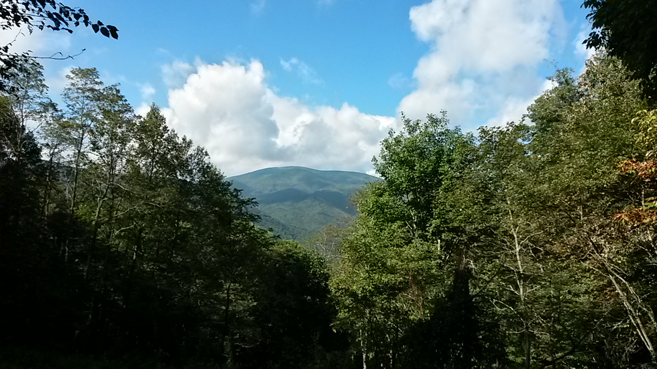
I climbed up Lovers Leap (1686'), an unnamed mountain (~2400'), Rich Mountain (3532'), and Spring Mountain (3538'). There were a few large elevation changes but also a lot of smaller ones throughout the day. It was a rough day on the body, particularly because of elevation gain and water being hard to come by. A lot of sources that are marked as steady were bone dry. I encountered water sources with enough to filter only twice. One of those sources was highly sulfuric and therefore difficult to keep down. Unfortunately, the hostel's water has both iron and sulfur; it's making it hard for me to stay hydrated because it tastes nasty. Had I realized the well water was like that, I might have tried filtering the water out of the creek on the property earlier to see if it's any better.

Halfway through my day, I took a break for about a hour at Rich Mountain's fire tower. It was sunny and breezy; it was nice to relax. Over the course of my day, I saw 3 day hikers, 4 weekend hikers, and 2 SOBOs.

I made it to Hemlock Hollow by around 4:45pm. They had basic resupply and some dinner things for sale. But they didn't have any fuel canisters. I nearly cried and swore a lot and looked despondent. The lady who works here said they'd been trying to get them for a while but the distributor the old owners used wouldn't deliver to the new owners. She then went and called around the local stores and found one 40 minutes away that sold Coleman canisters. She offered to, and then did, go to the store and buy a bunch of fuel canisters and sold me one at price. It really made my night; I'd started planning what I could do if I couldn't get a stove tonight and it was stressful. It involved some shenanigans tomorrow to get to another hostel that had fuel, or buy potatoes here and eat those for 2 dinners until I get to another hostel that sells fuel. I'm so glad I didn't have to deal with that.

Tomorrow, I'll have another two big climbs: one first thing in the morning, the second at the end of my day. A slackpacker here at the hostel said the water sources are poor, with only two flowing that he saw. So I'm going to load up on the nasty water here and hope for the best. I'll be back on the trail by 7:15am tomorrow morning and hiking slowly towards easier trail.

Friday, September 23, 2016

Final M-M hike

Friday, September 16, 2016
Start: 200 Harris Mountain Road, Granby, MA
End: 153 Packardville Rd Pelham, MA 01002
Miles: ~6.7

I started at the Harris Mountain trailhead around 8:30am. I hiked through the woods for a bit, crossed Bay Road, and then did some small ups and downs. I emerged onto Orchard Rd and Federal St. There was over a mile of road walking along Federal and then over two miles of road walking along Gulf Rd. At Gulf and North Gulf Roads, the trail reentered the woods for maybe half a mile before arriving at Packardville Rd at 11:15am. I hung out and read my book until my ride came to pick me up at 11:45am.

And just like that, I've hiked from Connecticut's Long Island Sound up to New Hampshire's Mount Monadnock along the Menunkatuck, Metacomet, and Metacomet-Monadnock Trails.

Sunday, September 11, 2016

M-M overnight hike, day #1

Friday, September 9, 2016
Start: Cross St/Rt 2 - Farley
End: Fall Brook shelter, MA/NH line
Miles: 25.4 (with ~6,700 ft elevation gain)

I started out at 8am from Cross St. I climbed Rattlesnake Mountain, Hermit Mountain, and Stratton Mountain. I stopped for lunch around 11:30-12 at the Richardson Cabin. It had a beautiful view with Mt Monadnock in the distance. It had two picnic tables and a Porta - potty,  as well as two tent pads, a cabin that sleeps ~6, wash tub for dishes, a laundry line, and a fire ring. Unfortunately, the only water was in a 5 gallon jug locked in the cabin so I couldn't resupply here. I then climbed over Little Mt Grace and Mt Grace, where there was a fire tower at the summit.

I stopped briefly at the Mt Grace Shelter from 3:15-3:30pm, which recently had a new roof installed since the past one was leaking. Initially I thought there was no water source but as I left, I found the small creek and resupplied there before heading out towards the Fall Brook shelter 9 miles away. I passed by Richards Reservoir inside Warwick State Forest on my way to the shelter, and used an old road walk portion of the M-M to cut off 1.3 miles of the new M-M trail so I could arrive at my evening's destination before dark. I arrived at the shelter by 7:15pm. While there is no privy, there is a water source for the shelter, though it is stained orangey brown by the dead pine needles that have fallen into it.

I've had a nice, relaxed dinner of a Rice Side, Cabot chedder, fruit snacks, cool ranch Doritos, and Oreos. And it turns out Rice Sides will cook quite nicely if you dump them into a freezer bag, add the boiling water, and let them sit for maybe 20-30 minutes. It's a super easy, no-mess way to make that kind of dinner. It left me with no pot to clean which made me happy.

I've decided to sleep in the shelter as it might rain tonight (also, there's nowhere to tent not on a sharp downward slant with rocks). It's pretty nice and no one else is here. There's a porch and two bunk beds, each bunk able to hold 2 people (so 8 people), in addition to a loft with another sleep area accessible by wooden ladder.

Tomorrow, I'll hike from here to Mt Monadnock (~18 miles). On the way, I'll hike directly through Troy and I'm hoping to enjoy some Thai food in town for lunch!