Tuesday, August 6, 2013

Metacomet trail - Part 5

This hike occurred on August 3, 2013
Trail Head:
West Peak Dr., Meriden, CT - Parking: Using the Hubbard Park auto road, we parked at the top of the Hanging Hills' West Peak and did a loop hike.  


Length/Distance: According the Connecticut Walk book, the route was 1.2 miles. According to my GPS tracking program, our route was 2.24 miles, which included a non-trail road walk to complete the loop.

Summary: Near the trail head where we parked our car, we saw some beautiful yellow flowers. They were Jerusalem Artichoke (Helianthus tuberosus), also known as Sunchokes. They have edible tubers similar to potatoes with a slightly sweet, nutty flavor.

Around the flowers, we saw both honeybees and hoverflies. 
 
Along the road, we found Indian Pipes (Monotropa uniflora) as well. They are edible but potentially toxic eaten in larger quantities.
We saw some pink Long-bristled Smartweed (Polygonum caespitosum) by the trail head next to Castle Craig. 
As well as some purple Great Burdock (Arctium lappa). 
There was also some white flowers that were probably Carpetweed (Mullugo verticillata).
Soon after the trail enters the woods, there were some beautiful views, including a wonderful view of Sleeping Giant. 
We saw Low-bush Blueberries and American Red Raspberries at the peak. There was also mysterious plant with berries we didn't recognize. 
There was a cool fissure in the cliff. 
We saw more interesting, unidentified berry plants. 
After this, the trail began to dip down a bit. 
The trek downward was difficult because the rocks were very unstable and prone to crumbling and falling. 

The trail then began to climb back up. 
There was quite a significant drop off to the left side of the trail. 
The climb continued as the woods opened up to a rocky area. 
On the other side, there was a cliff. 
At the top of this, there was an odd cave-like place between a few large rocks. 
We saw some Wood Anemone (Anemone quinquefolia).
After a bit more climbing, we reached West Peak. There were many radio towers. 
Overall, this hike was enjoyable. The trail was not difficult to follow and while the steep up and down was a bit tiring, it wasn't a long hike. We also found out that if the auto road gate is closed (when it should be open), you're supposed to ask the life guards at the public pool and they can open the gate. 

Wednesday, July 31, 2013

Metacomet trail - Part 4

This hike occurred on July 27, 2013


Trail Heads:

400 Park Dr., Berlin, CT - Parking: Given our past experience with the auto road, we initially assumed we would not be able to access the peak inside Hubbard park by car so we parked on Park Dr back beyond the "no parking beyond this sign." We walked to the gate and were very aggravated to see cars and motorcycles riding up the auto road. So we turned around, got in our car, and drove 10 minutes around the park to enter via the auto road. We had a friend pick us up from this location at the end of our hike and bring us back to our car. On this road, we saw some awesome Castle Crashers art. 

Peak Dr., Meriden, CT - Parking: Using the Hubbard Park auto road, we parked at the top of the Hanging Hills' East Peak, near Castle Craig.  

Length/Distance: According the Connecticut Walk book, the route was 1.1 miles. According to my GPS tracking program, our route was 1.8 miles. After much deliberation, we've come to the determination that we think the Connecticut Forest & Park Association measures trail distance according to 2D maps, not the actual 3D mileage.  

Summary: We began our hike from Peak Drive and the turret. 
There were some beautiful views from the top of Castle Craig. 

You could see a clear view of Sleeping Giant State Park in the distance (giant's head to the right with the feet to the left). 
There was a good view of Mirror Lake. 
After taking pictures, we headed out on the blue trail. If you head out from the turret, the trail is on your right a few hundred yards away. The blue trail crosses over the white trail and then has more amazing views. As we were looking at the view, we realized that an inventive Eastern Ratsnake (Pantherophis alleghaniensis) was sunning itself in an evergreen bush around shoulder height and we had disturbed it (its head is dead center of the photo). 
There was also an interesting chasm between two cliffs. 
Along this trail, there were amazing views of the Merimere Reservoir.   
There was also a proliferation of ripe American Red Raspberry (Rubus idaeus) along the trail.
The trail passed over an old stream bed that had run over rock.
The trail emerged onto the auto road to pass by the base of the Merimere Reservoir. 
There was also some beautiful Queen Anne's Lace (Daucus carota) [which I've somehow forgotten is another name for wild carrots and the taproot is edible, though the leaves are toxic and can irritate skin]. 
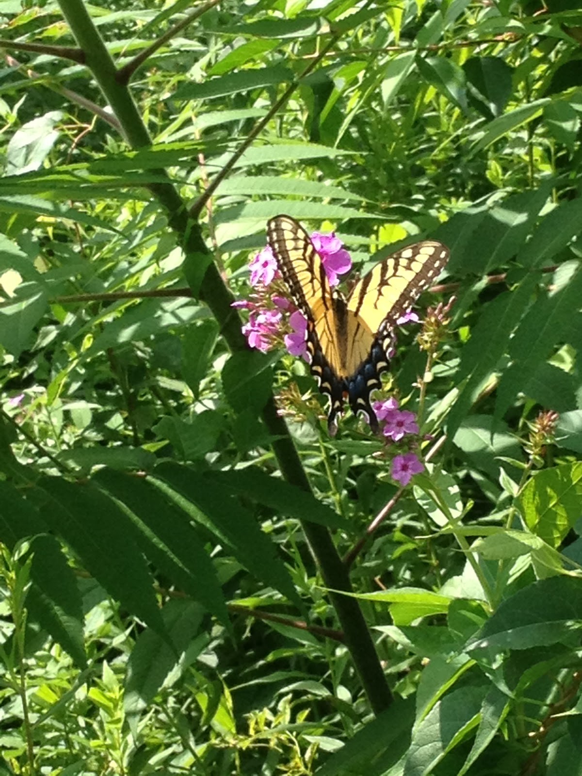
We then left Hubbard Park via Park Drive and walked along the road to meet our friend who was picking us up. Along the way, we saw some beautiful Perennial Phlox (Phlox paniculata).
There was a female Eastern Tiger Swallowtail Butterfly (Papilio glaucus) drinking nectar from these flowers. 


Overall, the hike was fairly short and mostly downhill. The parking/road situation around Hubbard Park is very frustrating, given the inconstant accessibility. Since the next section of trail climbs one of the highest peaks on the Metacomet trail (West Peak - 1,024 ft elevation), we'll be splitting it into two hikes. 

Tuesday, July 30, 2013

Sleeping Giant - Triangle and Circle trails

This hike occurred on July 26, 2013
Trail Head:
Mt Carmel Ave & Outer Ridge Rd, Hamden, CT - Parking: There is a parking lot on Mt Carmel Ave with room for maybe 3 cars to park off the road. The entrance to Circle trail is accessible either from the road or from a connector trail from the parking lot. We were originally going to start the hike from Triangle trail by Hogan Rd but there is absolutely no parking. We left one car here and did one large loop. 

Length/Distance: 
We completed a loop hike, taking the Circle trail through to Tuttle Ave then Triangle trail back which was slated to be around 3-4 miles. According to my GPS tracking program, our route was 3.77 miles, not including the half-mile walk back to the Circle trail parking lot.   

Summary: We started the hike up the connector trail from the parking lot. The connector trail wasn't marked at all but follow it to the left and it connects with Circle trail. There was quite a bit of flora by the trail. We saw Narrow-Leaf Mountain Mint (or Slender Mountain Mint) (Pycnanthemum tenuifolium). Apparently, the dried leaves can be used as a flavorant in tea or cooking. It can be used as an insect repellent, though its cousin is better.  
Circle trail wound around the giant's right leg and knee and left leg. 
There had been a fair amount of rain lately and there was water running in creek beds that didn't typically have water. 
We also happened upon a camp site. Now, normally camping is not allowed on Sleeping Giant but if a non-profit organization or kids' camp wants to camp, they can get a permit. We did not know this so we called the DEEP and told them about the abandoned camp. They came out, took at look at it, contacted the owner of an abandoned trailer with camping supplies on it, and found out they were camping there legally as part of a non-profit kids' camp. The DEEP officer was kind enough to call us and let us know. 
The site was quite a mess though. We think they abandoned camp part way through their stay due to the rain. 
Right around here, there was the Gorge Cascade. It's a lot further down than it looks. 
We hit the bottom of the Circle trail and connected through to the Triangle trail via the horseback riding trail (U). The Triangle trail was a never-ending uphill climb up and over the giant's hips. 
There were some Intermediate Woodfern (Dryopteris intermedia) along the trail. 
Between the Orange and the White trails, there was a large tree down on Triangle trail. 
Towards the end of this hike, there was a nice wood bridge over a creek bed. 
From there, the trail exited onto the side of Mt Carmel Ave. We trekked back to our car at the base of the Circle trail.

Overall, it was a good but tiring hike. The Triangle trail was especially steep and had a very prolonged assent. It had been raining earlier in the day but had stopped prior to the beginning of the hike though it did drizzle on us during the middle of the hike.